Please be advised that due to the upcoming holiday season, delivery times may be extended as courier services experience increased volumes. We appreciate your patience.


Please be advised that due to the upcoming holiday season, delivery times may be extended as courier services experience increased volumes. We appreciate your patience.
+1 (724) 923-6024


📩 Digital product.
The license key will be delivered by email within 24 hours after purchase.
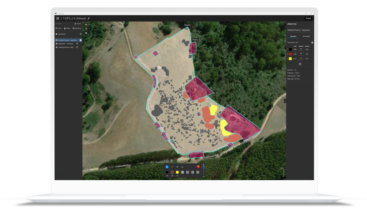
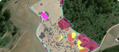
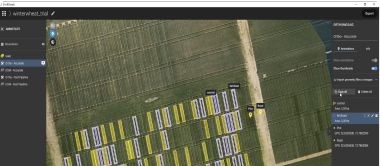
Ready-to-use & customizable variable rate and spot spraying maps for spray drones, tractors, and field sprayers. ISOXML for standard ISOBUS machine terminals.
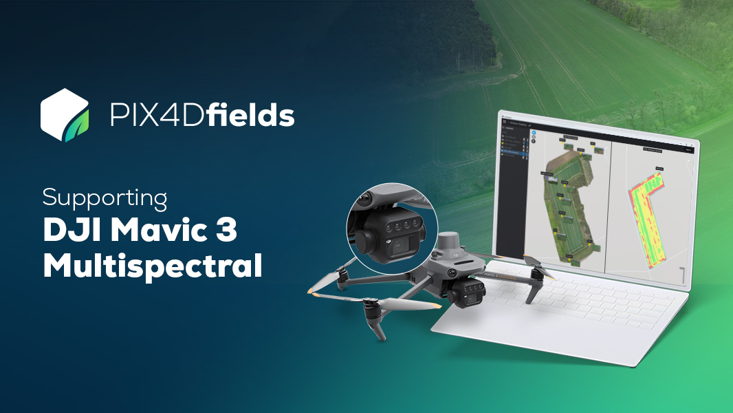
Try a DJI Mavic 3 Multispectral demo dataset yourself! Process it with PIX4Dfields and let the magic happen. Start saving time, money, and resources in your agriculture workflows today!
Overcome the challenges of modern agriculture with the innovative Pix4Dfields Software for Desktop Application. This high-tech, advanced, and powerful software is designed specifically for educational purposes, providing students and educators with a comprehensive toolset for learning about photogrammetry and remote sensing.
The Pix4Dfields Software is a user-friendly platform that allows you to capture images using a drone and any standard RGB or selected multispectral camera like Parrot Sequoia+ and MicaSense RedEdge. Our Pix4Dcapture app makes planning and controlling your drone flight for optimal mapping a breeze.
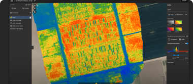
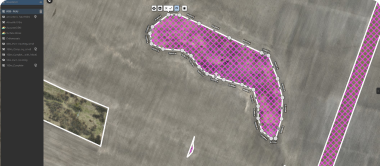
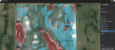
The software's instant processing engine allows you to process imagery and generate maps directly in the field. It can handle 6.8 GB, 2948 images in just 10 minutes with the new radiometry module. This powerful tool enables you to generate precise orthomosaics, digital surface models, index maps, zones, and accurate prescription maps.
With Pix4Dfields, you can visualize and understand your crop growth stages and stress levels. Analyze and compare different layers of information for a full insight into your yield performance. Use these insights to increase crop production and reduce costs.
The software also allows you to share your maps with all project stakeholders for seamless collaboration using the Pix4Dfields PDF report tool. You can download all outputs, results, and insights and import them into the Farming Management Software of your choice in various industry-standard formats.
Pix4Dfields is the only digital agriculture software that focuses on reducing processing time while incorporating the highest accuracy standards backed up by years of scientific research. It enables you to create maps rapidly (no internet connection required) for faster decision making and action, without leaving the field.
The software connects your data to platforms like the John Deere Operations Center, synchronizing and accessing your data in-office and in-field for streamlined collaboration. With Pix4Dfields, you can inspect, analyze, and visualize your crop changes all year round.
The software supports the import of images collected from multispectral sensors like Parrot Sequoia and the MicaSense RedEdge family, as well as standard RGB sensors. You can also import pre-processed maps, field boundaries, and annotations.
Pix4Dfields is designed to elevate education and academic research with photogrammetry. It allows you to teach photogrammetry with Pix4Dmapper's unique rayCloud environment and enhance your curriculum or design your courses with our unparalleled knowledge base, open-access online exercises, and videos.
Experience the future of digital farming with the Pix4Dfields Software for Desktop Application.
📩 Digital product.
The license key will be delivered by email within 24 hours after purchase.
Ready-to-use & customizable variable rate and spot spraying maps for spray drones, tractors, and field sprayers. ISOXML for standard ISOBUS machine terminals.
Try a DJI Mavic 3 Multispectral demo dataset yourself! Process it with PIX4Dfields and let the magic happen. Start saving time, money, and resources in your agriculture workflows today!
Overcome the challenges of modern agriculture with the innovative Pix4Dfields Software for Desktop Application. This high-tech, advanced, and powerful software is designed specifically for educational purposes, providing students and educators with a comprehensive toolset for learning about photogrammetry and remote sensing.
The Pix4Dfields Software is a user-friendly platform that allows you to capture images using a drone and any standard RGB or selected multispectral camera like Parrot Sequoia+ and MicaSense RedEdge. Our Pix4Dcapture app makes planning and controlling your drone flight for optimal mapping a breeze.
The software's instant processing engine allows you to process imagery and generate maps directly in the field. It can handle 6.8 GB, 2948 images in just 10 minutes with the new radiometry module. This powerful tool enables you to generate precise orthomosaics, digital surface models, index maps, zones, and accurate prescription maps.
With Pix4Dfields, you can visualize and understand your crop growth stages and stress levels. Analyze and compare different layers of information for a full insight into your yield performance. Use these insights to increase crop production and reduce costs.
The software also allows you to share your maps with all project stakeholders for seamless collaboration using the Pix4Dfields PDF report tool. You can download all outputs, results, and insights and import them into the Farming Management Software of your choice in various industry-standard formats.
Pix4Dfields is the only digital agriculture software that focuses on reducing processing time while incorporating the highest accuracy standards backed up by years of scientific research. It enables you to create maps rapidly (no internet connection required) for faster decision making and action, without leaving the field.
The software connects your data to platforms like the John Deere Operations Center, synchronizing and accessing your data in-office and in-field for streamlined collaboration. With Pix4Dfields, you can inspect, analyze, and visualize your crop changes all year round.
The software supports the import of images collected from multispectral sensors like Parrot Sequoia and the MicaSense RedEdge family, as well as standard RGB sensors. You can also import pre-processed maps, field boundaries, and annotations.
Pix4Dfields is designed to elevate education and academic research with photogrammetry. It allows you to teach photogrammetry with Pix4Dmapper's unique rayCloud environment and enhance your curriculum or design your courses with our unparalleled knowledge base, open-access online exercises, and videos.
Experience the future of digital farming with the Pix4Dfields Software for Desktop Application.
Couldn't load pickup availability


