


About
Description
PiX4D PiX4Dreact Software Perpetual license
📩 Digital product.
The license key will be delivered by email within 24 hours after purchase.
The map you need when you need it
Ensure teams and decision makers are provided with timely and effective information needed to take action
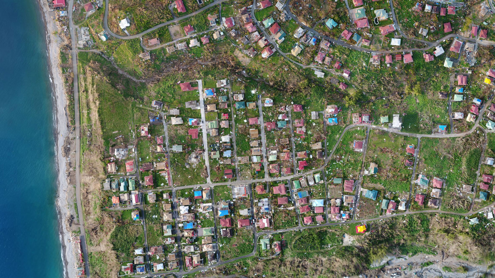
2D orthomosaic map
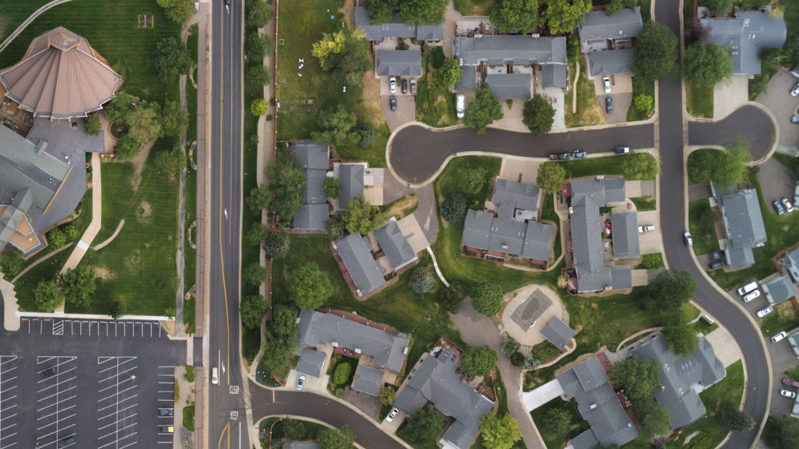
PIX4Dreact uses fast-stitching technology to create accurate 2D orthomosaic maps by combining a large number of nadir drone images.
Export format: geoTIFF
Markers and measurements
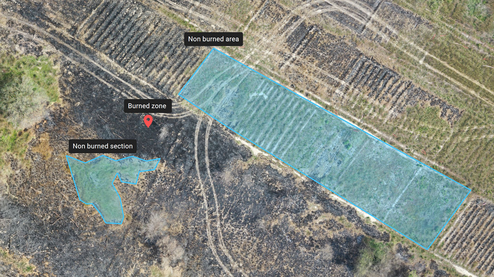
Mark areas of interest or GPS coordinates within the project and assess the situation on the ground for smoother collaboration or long-term documentation.
Markers export formats: GeoJSON, KML, Shapefile
Measurements export format: PDF
Screenshots and whole maps
Document and collaborate in seconds with options to export your maps as screenshots or a whole map that can be imported into PIX4Dreact on another computer.
Screenshots export format: JPEG
Whole maps export format: p4r
Pix4D Pix4Dreact Features
- Desktop application with floating license (use on 1 device)
- Unlimited desktop processing
- Personal support and updates
Pix4Dreact creates 2D maps from aerial imagery in minutes. Because when every second counts, up-to-date and reliable information is of utmost importance to teams on the ground.
Easy to use
Simple and intuitive to use, even in complex and stressful situations. Pix4Dreact is developed with public safety and humanitarian aid professionals to meet their unique challenges.
Lightweight and robust
Lightweight enough to work on a mid-range computer in the field. Pix4Dreact doesn't rely on an internet connection or the cloud for processing.
Intuitive workflow
Pix4Dreact is designed to be intuitive and simple to use, even for people with little or no drone flight or photogrammetry experience. In complex and evolving environments, creating, documenting and sharing maps is made accessible to any emergency responder.
Document, annotate, and compare maps
Connect your maps with what you see on the ground. Rely on powerful rapid insights directly from the field and easily mark and measure points of interest.
Share in seconds
Share 2D orthomosaic maps and annotations as a PDF reports which are lightweight enough to send over email. You can also pinpoint and export a single aerial image of an area of interest.
Fit for purpose
Pix4Dreact is stand-alone 2D fast-mapping software, tailor-made for emergency response. It can be used independently or as a companion to Pix4Dmapper, the leading 2D and 3D photogrammetry software for survey-grade reconstruction tasks.
Inputs
RGB images
Import a large number of nadir images from standard RGB sensors in JPG format.
Pre-processed maps
Import orthomosaics already processed in other Pix4D products (import as geoTIFF).
Markers
Import markers/annotations that have been generated with other apps and overlay them in your project (import as GeoJSON).
Tools & Functionalities
Easy to use interface
An easy to use and intuitive interface, developed with public safety and humanitarian aid professionals.
Fast mapping
Generate high-resolution up-to-date and reliable 2D maps from aerial imagery in minutes.
Marker tool
Place point, line, and area markers to identify and export points of interest.
Measure tool
Quickly measure distances and areas for accurate tactical and mission planning. Save as markers when needed to make the measurements permanent.
Comparison tool
Compare different maps side-by-side using split or double screen.
PDF report generator
Share your maps with all project stakeholders for seamless collaboration using the PDF report export tool.
Export tool
Select some or all layers in your project and export them into a predefined folder on your computer.
Lightweight and robust
Lightweight to work on a mid-range computer in the field. Pix4D doesn't rely on an internet connection or the cloud for processing.
Output
Orthomosaic
An intuitive representation of the situation on the ground for smoother collaboration or long-term documentation.
Digital surface model
See elevation data to help with movement of personnel on the ground and estimate flooding prone areas (export as geoTIFF).
Markers and measurements
Adding markers to areas of interest helps convey more valuable and actionable information (export as PDF and GeoJSON).
DF report
Easily export a 2D orthomosaic, location data and markers in one file to share by WhatsApp or over email.
Multi-Lingual
Language Options
English, German, Japanese, and Spanish.
Description
PiX4D PiX4Dreact Software Perpetual license
📩 Digital product.
The license key will be delivered by email within 24 hours after purchase.
The map you need when you need it
Ensure teams and decision makers are provided with timely and effective information needed to take action
2D orthomosaic map
PIX4Dreact uses fast-stitching technology to create accurate 2D orthomosaic maps by combining a large number of nadir drone images.
Export format: geoTIFF
Markers and measurements
Mark areas of interest or GPS coordinates within the project and assess the situation on the ground for smoother collaboration or long-term documentation.
Markers export formats: GeoJSON, KML, Shapefile
Measurements export format: PDF
Screenshots and whole maps
Document and collaborate in seconds with options to export your maps as screenshots or a whole map that can be imported into PIX4Dreact on another computer.
Screenshots export format: JPEG
Whole maps export format: p4r
Pix4D Pix4Dreact Features
- Desktop application with floating license (use on 1 device)
- Unlimited desktop processing
- Personal support and updates
Pix4Dreact creates 2D maps from aerial imagery in minutes. Because when every second counts, up-to-date and reliable information is of utmost importance to teams on the ground.
Easy to use
Simple and intuitive to use, even in complex and stressful situations. Pix4Dreact is developed with public safety and humanitarian aid professionals to meet their unique challenges.
Lightweight and robust
Lightweight enough to work on a mid-range computer in the field. Pix4Dreact doesn't rely on an internet connection or the cloud for processing.
Intuitive workflow
Pix4Dreact is designed to be intuitive and simple to use, even for people with little or no drone flight or photogrammetry experience. In complex and evolving environments, creating, documenting and sharing maps is made accessible to any emergency responder.
Document, annotate, and compare maps
Connect your maps with what you see on the ground. Rely on powerful rapid insights directly from the field and easily mark and measure points of interest.
Share in seconds
Share 2D orthomosaic maps and annotations as a PDF reports which are lightweight enough to send over email. You can also pinpoint and export a single aerial image of an area of interest.
Fit for purpose
Pix4Dreact is stand-alone 2D fast-mapping software, tailor-made for emergency response. It can be used independently or as a companion to Pix4Dmapper, the leading 2D and 3D photogrammetry software for survey-grade reconstruction tasks.
Inputs
RGB images
Import a large number of nadir images from standard RGB sensors in JPG format.
Pre-processed maps
Import orthomosaics already processed in other Pix4D products (import as geoTIFF).
Markers
Import markers/annotations that have been generated with other apps and overlay them in your project (import as GeoJSON).
Tools & Functionalities
Easy to use interface
An easy to use and intuitive interface, developed with public safety and humanitarian aid professionals.
Fast mapping
Generate high-resolution up-to-date and reliable 2D maps from aerial imagery in minutes.
Marker tool
Place point, line, and area markers to identify and export points of interest.
Measure tool
Quickly measure distances and areas for accurate tactical and mission planning. Save as markers when needed to make the measurements permanent.
Comparison tool
Compare different maps side-by-side using split or double screen.
PDF report generator
Share your maps with all project stakeholders for seamless collaboration using the PDF report export tool.
Export tool
Select some or all layers in your project and export them into a predefined folder on your computer.
Lightweight and robust
Lightweight to work on a mid-range computer in the field. Pix4D doesn't rely on an internet connection or the cloud for processing.
Output
Orthomosaic
An intuitive representation of the situation on the ground for smoother collaboration or long-term documentation.
Digital surface model
See elevation data to help with movement of personnel on the ground and estimate flooding prone areas (export as geoTIFF).
Markers and measurements
Adding markers to areas of interest helps convey more valuable and actionable information (export as PDF and GeoJSON).
DF report
Easily export a 2D orthomosaic, location data and markers in one file to share by WhatsApp or over email.
Multi-Lingual
Language Options
English, German, Japanese, and Spanish.
PIX4D
by
PIX4D
PiX4D PiX4Dreact Software Perpetual license
- Regular price
- $790.00
- Sale price
- $790.00
- Regular price
-
Shipping calculated at checkout.
Providing the best new Tech Experience, Energy Independence and Robotics Ways of Optimisation
Providing the best new Tech Experience, Energy Independence and Robotics Ways of Optimisation
Couldn't load pickup availability
Packaging note:
Equipment is being supplied in a manufacturer packaging


